|
Biodiversity Information Science and Standards : Conference Abstract
|
|
Corresponding author: Benedictus Freeman (benedictusfreeman@gmail.com)
Received: 25 Jun 2019 | Published: 02 Jul 2019
© 2019 Benedictus Freeman, A. Townsend Peterson
This is an open access article distributed under the terms of the Creative Commons Attribution License (CC BY 4.0), which permits unrestricted use, distribution, and reproduction in any medium, provided the original author and source are credited.
Citation: Freeman B, Peterson A (2019) Primary Biodiversity Data Gaps Assessment and Data Use for Decision-making: A West African Experience. Biodiversity Information Science and Standards 3: e37685. https://doi.org/10.3897/biss.3.37685
|
|
Abstract
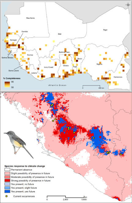
Primary biodiversity data, data documenting presences of particular species at particular sites at a point in time, available in standard digital formats, provide the basis for many quantitative studies that can inform effective and reliable national, regional, and global biodiversity conservation decisions. However, these datasets are often unavailable, incomplete, or unevenly distributed across regions and landscapes. We assessed the survey completeness and gaps in current knowledge of birds of West Africa, using digital, accessible primary biodiversity data, obtained from the Global Biodiversity Information Facility and eBird. Additionally, using ecological niche modeling approaches, we modeled the current and potential future geographic distributions of a diverse suite of range-restricted and ecologically important bird species, and used the resulting models to identify priority areas for conservation and future surveys (Fig.
Keywords
conservation planning, biodiversity inventory completeness, biodiversity informatics, climate change, range-restricted species, ecological niche modeling
Presenting author
Benedictus Freeman
Presented at
Biodiversity_Next 2019