|
Proceedings of TDWG : Conference Abstract
|
|
Corresponding author: Andrew Sherin (coinatlantic@dal.ca)
Received: 09 Aug 2017 | Published: 10 Aug 2017
© 2017 Andrew Sherin, Bruce Hatcher, Mary Kennedy, Jeff McKenna, Nicholas Doane, Caelin Murray, Brittany MacGillivray, Paul Boudreau
This is an open access article distributed under the terms of the Creative Commons Attribution License (CC BY 4.0), which permits unrestricted use, distribution, and reproduction in any medium, provided the original author and source are credited.
Citation: Sherin A, Hatcher B, Kennedy M, McKenna J, Doane N, Murray C, MacGillivray B, Boudreau P (2017) Sydney Harbour Atlas. Proceedings of TDWG 1: e20157. https://doi.org/10.3897/tdwgproceedings.1.20157
|
|
Abstract
The estuarine harbour of Sydney, Nova Scotia on the island of Cape Breton has supplied goods and services to humans since the Holocene transgression. As an urban marine ecosystem and strategically located maritime port, it has supported commercial fisheries, military campaigns, and coal and steel industries since the 16th century. Now in the post-industrial era of the Anthropocene, the good burghers of Sydney seek to re-vitalize the commercial port while maintaining the natural assets of the harbour. The recent completions of the tar ponds remediation, the dredge realignment of the shipping channel and creation of a large, new industrial surface, benchmark the next phase in the history of the Harbour.
The objective of the Sydney Harbour Atlas (Fig.
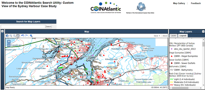
Partial screen grab (search and additional information windows not shown) of the Sydney Harbour Atlas.
This paper presents the initial effort to create a Sydney Harbour Atlas in a partnership between the Coastal and Ocean Information Network Atlantic’s (COINAtlantic) and the Bras D’Or Institute of Cape Breton University. COINAtlantic’s mission is to promote, facilitate and influence information management, policies and programs that enhance Integrated Coastal and Ocean Management in Atlantic Canada (
A customized version of the COINAtlantic Search Utility (CSU) (http://coinatlantic.tools/csu/?mapset=sydney_harbour) has been developed to visualize the map layers assembled for the Atlas. The CSU is a search engine which uses the Google Search API to crawl its index for related spatial data in KML and WMS (Web Mapping Service) format, and then displays the results. The CSU also generates an internal data base of WMS and KML spatial data resources from the search results. This data base can be searched as an alternative to searching with the Google Search API (there are over 3,400 records in the data base pointing to remote geospatial services). The CSU enables the user to add any other WMS that is found by using the tool’s search function or known to the user so that the species occurrence data can be viewed in its spatial and / or environmental context.
Version 1 of the Sydney Harbour Atlas displays, at opening, map layers from 4 main sources (see Table
Examples of map layers for the Sydney Harbour Atlas by type of web mapping service.
|
Map Layer |
Source organization |
|
Remote Government Web Mapping Services |
|
|
Canadian Marine Multibeam Bathymetric Data Web Map Service (WMS) |
Government of Canada Natural Resources Canada |
|
Roads at 1:10,000 scale |
Province of Nova Scotia, GeoNOVA |
|
Cape Breton Regional Municipality (CBRM) via COINAtlantic Mapping Service |
|
|
Sewer Outfalls |
CBRM via Bras D’Or Institute |
|
OBIS Canada IPT COINAtlantic Web Mapping Service |
|
|
Meroplankton of Sydney Harbour |
Cape Breton University |
|
COINAtlantic Web Mapping Service |
|
|
Green Crab (Carcinus maenas) |
Bras D’Or Institute |
Future developments include the addition of more ecosystem relevant map layers, the publication of OGC compliant Web Feature Services that would permit the user to stylize and analyze the data in their own GIS environment, the improvement of the layers window to provide easier user access to the many layers without scrolling, and expanding the richness of the metadata displayed in the “Additional Layer Information” window.
Keywords
Atlas, web mapping services, urban ecosystem
Presenting author
Andrew Sherin, Director, COINAtlantic Secretariat
Author contributions
Bruce Hatcher, Bras D’Or Institute, Cape Breton University
Andrew Sherin, COINAtlantic
Mary Kennedy, OBIS Canada
Jeff McKenna, Gateway Geomatics
Brittany MacGillivray, COINAtlantic
Paul Boudreau, International Ocean Institute Canada
Caelin Murray, Bras D’Or Institute, Cape Breton University
Nicholas Doane, COINAtlantic
References
-
COINAtlantic – A better way to implement a geospatial portal.Directions MagazineURL: http://www.directionsmag.com/entry/coinatlantic-a-better-way-to-implement-a-geospatial-portal/425845