|
Proceedings of TDWG : Conference Abstract
|
|
Corresponding author: Andrew Sherin (coinatlantic@dal.ca)
Received: 09 Aug 2017 | Published: 10 Aug 2017
© 2017 Andrew Sherin, Jeff McKenna, Paul Boudreau, Mary Kennedy, Brittany MacGillivray
This is an open access article distributed under the terms of the Creative Commons Attribution License (CC BY 4.0), which permits unrestricted use, distribution, and reproduction in any medium, provided the original author and source are credited.
Citation: Sherin A, McKenna J, Boudreau P, Kennedy M, MacGillivray B (2017) Spatial Visualization of Publicly Accessible Species Occurrence Data. Proceedings of TDWG 1: e20155. https://doi.org/10.3897/tdwgproceedings.1.20155
|
|
Abstract
The Coastal and Ocean Information Network Atlantic’s (COINAtlantic) mission is to promote, facilitate and influence information management, policies and programs that enhance Integrated Coastal and Ocean Management (ICOM) in Atlantic Canada. A project to support this mission has been underway since 2014 with principle funding from the Atlantic Ecosystem Initiative (Environment and Climate Change Canada) and in the last year also from the Department of Fisheries and Ocean to rescue and make accessible to the public and other researchers, species occurrence data using the Ocean Biogeographic Information System Canada (OBIS Canada) Information Publishing Tool (OBIS Canada IPT).
Over 300 data resources of marine species occurrences were identified and cataloged and prioritized for processing according to OBIS standards.
Using on-line tools developed by COINAtlantic and modified for this project, the data resources published by the project to the OBIS Canada IPT and all the other public data resources were made available as internet searchable web mapping services.
Once a day, a scripted process interrogates the OBIS Canada IPT data resources and builds an Open Geospatial Consortium (OGC) Web Mapping Service using MapServer (http://mapserver.org), one map layer for each data resource, and a KML file that provides a bounding box and linkages to the full data resource and metadata on the OBIS Canada IPT. MapServer is an Open Source platform for publishing spatial data and interactive mapping applications to the web.
The KML files are searchable on the internet and the WMS is available for use by any capable GIS system with access to the internet.
A customized version of the COINAtlantic Search Utility (CSU) (http://coinatlantic.tools/csu/?mapset=acmsd2015) has been developed to visualize the map layers generated by the process (see Fig.
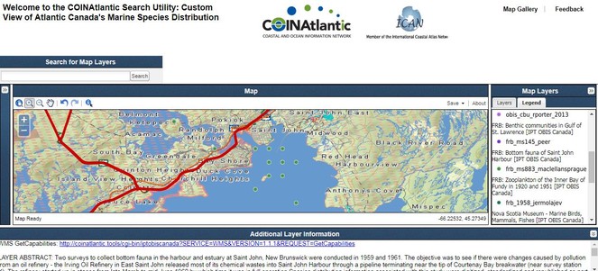
A partial screen grab (search windows are absent) of the customized CSU showing the map layer “Bottom fauna of Saint John Harbour” (green dots) with the detailed topographic map layer provided to the internet by the Province of New Brunswick.
Future developments include the possible deployment of the process to IPTs other than the OBIS Canada IPT, the publication of OGC compliant Web Feature Services that would permit the user to stylize and analyze the data in their own GIS environment, the improvement of the legends generated by the automatic legend generation process, expanding the richness of the metadata displayed in the “Additional Layer Information” window, and exposing the CSU’s internal data base to internet searches using the OGC compliant standard Catalog Service on the Web (CSW).
Keywords
Spatial data accessibility, visualization, open source software, web mapping service
Presenting author
Andrew Sherin
References
-
COINAtlantic – A better way to implement a geospatial portal.Directions MagazineURL: http://www.directionsmag.com/entry/coinatlantic-a-better-way-to-implement-a-geospatial-portal/425845